Pasargadae is region in 120 km Shiraz, which Iranians and the people of around the world know by Cyrus the Great and Achaemenid rule. Cyrus the Great has chosen Pasargadae as the capital of his government, and according to the Roman historian, caving and the inscriptions of the palace, it can be understood that he ordered to build this area. This complex was registered in 2004 on the UNESCO World Heritage List and includes palaces, Cyrus the great tomb, Cambyses tomb and Mozaffari's caravanserai. The tomb of Cyrus the Great Cyrus is the great king of history who calls him as a wise king and he is popular among all the people of the world. The tomb of Cyrus is the most well-known building in the area and many tourists all around Iran and whole the world come to Pasargadae to visit it. In the past, the tomb of Cyrus was among the royal gardens, and now it remains after 25 centuries. A magnificent and normal building made by limestone which has 6 steps and a room with a sloping roof over it. It should be noted that the construction of this building has not been used any mortar and what is connected the rocks is a special type of clamp, which at that time was a popular technique. There are different opinions about the architectural style of the tomb. Some believe that this style originates from Greek, Minor Asia, Egyptian, Elamite, Middle Rhode and Iranian architecture. This room was for the Maintenance of Cyrus body and looted by Alexander's invasion and then all the objects inside it were plundered. Before Islam the tomb of Cyrus was the coronation of the kings, but this place changed with the Arab invasion of Iran as its name changed to the tomb of
Pasargadae is region in 120 km Shiraz, which Iranians and the people of around the world know by Cyrus the Great and Achaemenid rule. Cyrus the Great has chosen Pasargadae as the capital of his government, and according to the Roman historian, caving and the inscriptions of the palace, it can be understood that he ordered to build this area. This complex was registered in 2004 on the UNESCO World Heritage List and includes palaces, Cyrus the great tomb, Cambyses tomb and Mozaffari’s caravanserai.
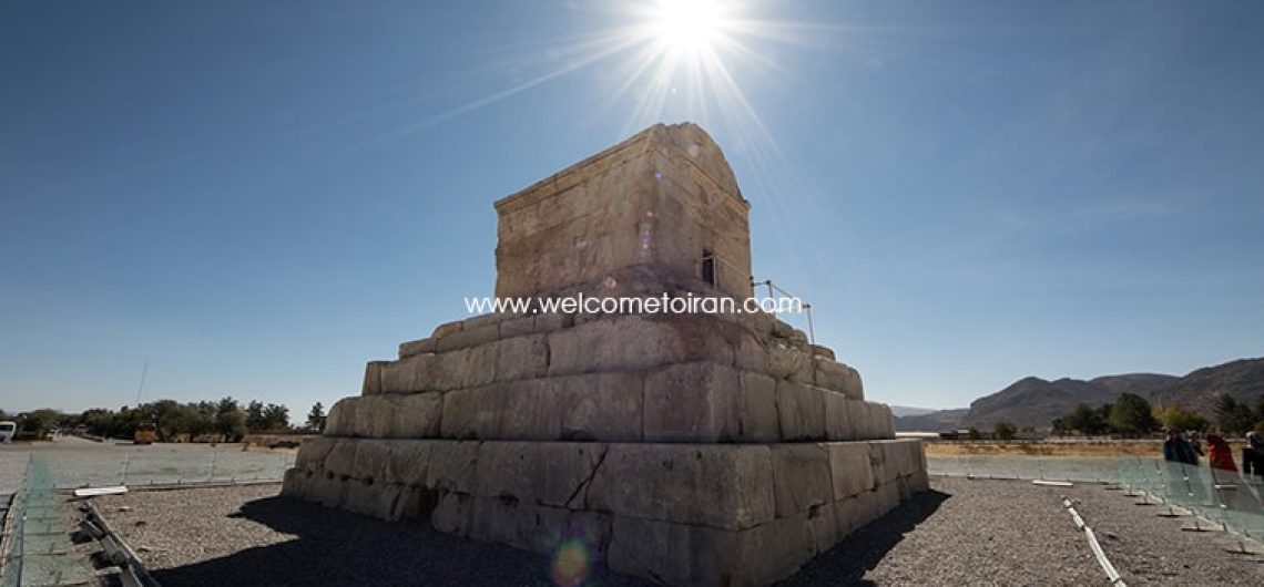
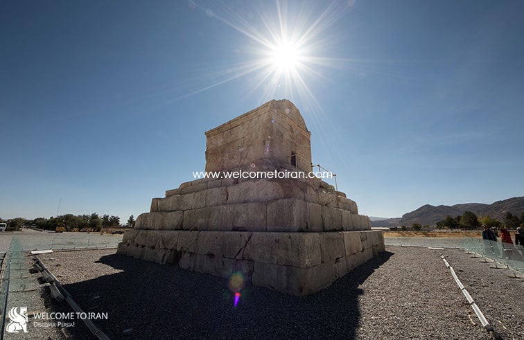
The tomb of Cyrus the Great
Cyrus is the great king of history who calls him as a wise king and he is popular among all the people of the world. The tomb of Cyrus is the most well-known building in the area and many tourists all around Iran and whole the world come to Pasargadae to visit it. In the past, the tomb of Cyrus was among the royal gardens, and now it remains after 25 centuries. A magnificent and normal building made by limestone which has 6 steps and a room with a sloping roof over it. It should be noted that the construction of this building has not been used any mortar and what is connected the rocks is a special type of clamp, which at that time was a popular technique. There are different opinions about the architectural style of the tomb. Some believe that this style originates from Greek, Minor Asia, Egyptian, Elamite, Middle Rhode and Iranian architecture.
This room was for the Maintenance of Cyrus body and looted by Alexander’s invasion and then all the objects inside it were plundered. Before Islam the tomb of Cyrus was the coronation of the kings, but this place changed with the Arab invasion of Iran as its name changed to the tomb of the mother of Prophet Solomon. Then the tomb became a holy place where many people came to pilgrimage and so they built a mosque and caravanserai near it.
The tomb of Cambyses
In the northern part of the Pasargadae palaces there is the Cambyses’ tomb or Alexander’s Prison. There are different opinions about this building, and since only one wall remains, there can be no doubt about its use. However, some scholars attribute it to the tomb of Cambyses, the father of Cyrus, some others believe in Cassandra the wife of Cyrus and some believe that this monument have been the royal or religious treasury of Cyrus.
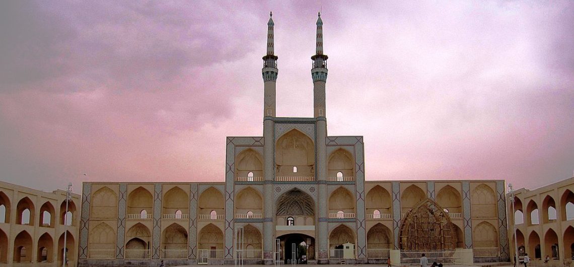
The Bar-e Am Palace
The Bar-e Am Palace was the place where the king met and welcomed his guests. In this palace, discussions were held on issues such as freedom, human rights and equality, and it was the kind of first United Nations center. Cyrus’s Cylinder first appeared in this place. The reliefs of this palace are symbolically employed, for example combination relief of human and cattle is a symbol of blessing and the combination relief of man and fish is a symbol of human domination over water.
Mozaffari Caravanserai
The Mozafari Caravanserai is located near the tomb of Cyrus, which dates back to Al-Muzaffar. The caravanserai has a number of small and large rooms that are used by the Cyrus Castle to build it. Gypsum mortar has been used to connect the rocks, and in some cases even mortar has not been used. The caravanserai is located eastward and behind it.
Dowlat Abad Garden was built at the end of the Afsharieh period as an accommodation for Yazd ruler, Mohammad Taghi Khan Bafghi. At that time the garden was out of town and mass trees created an pleasant atmosphere and were prevented the mansion being seen from outside. The trees continued at 5 meters and 20 kilometers long and was called “Hezar Derakht” (thousand trees). The urban space grew gradually so that Dowlat Abad Garden was located in the center of the city during the Pahlavi period.For providing water to the garden, one of longest qanat in Yazd were delved at a distance of 65 km, from Mehriz. This qanat plays a key role in the greenery and refreshment of the garden and also used for agricultural lands.Dowlat Abad Garden has used as an accommodation and governmental garden composed of two parts:An outer garden used for government and ceremonial purposes and an inner garden used as a residence and private sector. In the following, we will explain the different sections of the outer and inner gardens: Inner Garden (Andarooni) Hashti Mansion: This octagonal mansion is the most important building at the end of the garden. In this building, Iranian architects have used the water and climate mechanism to air moderate and condition and for this reason were called summer mansion. Windcatcher: The Dowlat Abad Garden with a height of 33.8 is the world's tallest Windcatcher. Below of this octagonal Windcatcher there is a pool when air passes through it, creates the water and climate mechanism and causes coolness around it. Inside the house there is decorating in roof, doors and windows. You can also the garden with fantastic view from the second floor. Tanabi Hall is located in west of Hashti Mansion which there is an underground which joins to under
Dowlat Abad Garden was built at the end of the Afsharieh period as an accommodation for Yazd ruler, Mohammad Taghi Khan Bafghi. At that time the garden was out of town and mass trees created an pleasant atmosphere and were prevented the mansion being seen from outside. The trees continued at 5 meters and 20 kilometers long and was called “Hezar Derakht” (thousand trees). The urban space grew gradually so that Dowlat Abad Garden was located in the center of the city during the Pahlavi period.For providing water to the garden, one of longest qanat in Yazd were delved at a distance of 65 km, from Mehriz. This qanat plays a key role in the greenery and refreshment of the garden and also used for agricultural lands.Dowlat Abad Garden has used as an accommodation and governmental garden composed of two parts:An outer garden used for government and ceremonial purposes and an inner garden used as a residence and private sector.
In the following, we will explain the different sections of the outer and inner gardens:
Inner Garden (Andarooni)
Hashti Mansion: This octagonal mansion is the most important building at the end of the garden. In this building, Iranian architects have used the water and climate mechanism to air moderate and condition and for this reason were called summer mansion.
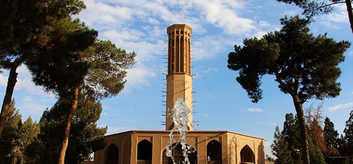
Windcatcher: The Dowlat Abad Garden with a height of 33.8 is the world’s tallest Windcatcher. Below of this octagonal Windcatcher there is a pool when air passes through it, creates the water and climate mechanism and causes coolness around it. Inside the house there is decorating in roof, doors and windows. You can also the garden with fantastic view from the second floor.
Tanabi Hall is located in west of Hashti Mansion which there is an underground which joins to under of Windcatcher.
Behesht Aein is located opposite of Hashti Mansion. This building is a winter mansion built to the south to sun and make warm. The characteristics of Iranian monuments are four seasons.
Outer garden
A small rectangle with different parts which is located in the northern part of the garden and was used for governmental ritual, inhabitation of caravans and sports events.
After the death of Mohammad Taqi Khan, the garden was t ruined and despite the repairs that took place it did not return to its previous position. Nonetheless, the Dowlat Abad garden is still shining in the desert like Emerald.
In 2011, Dowlat Abad Garden was registered as one of the Iranian gardens in the UNESCO Organization.
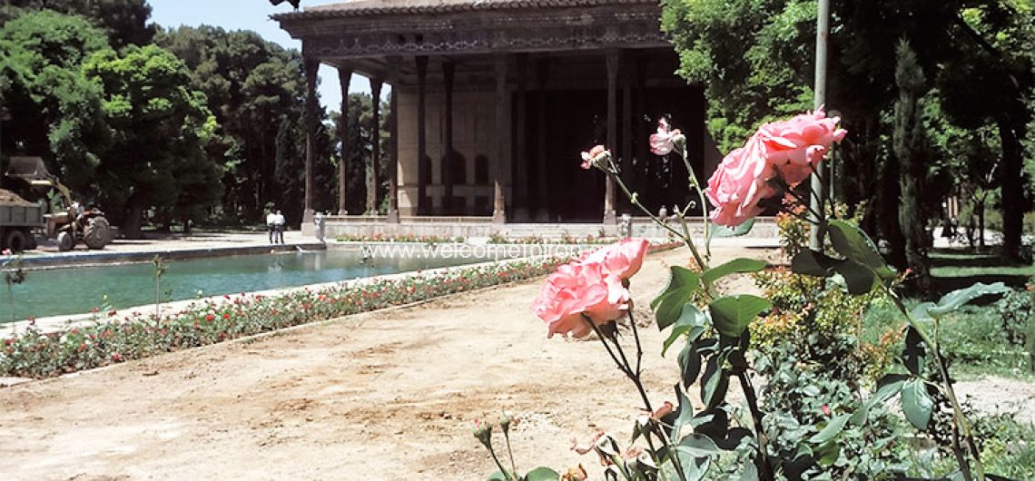
Chehel Sotoun is one of the ruins of the Safavid dynasty in the city of Isfahan, which is also known as the museum-garden. In fact, this garden is a small part of the Jahannama vast garden that Shah Abbas I created core of the Chehel Sotun palace by creation a palace in the midst of that with small rooms around it. The main porch is based on twenty pillars. Many researchers recognize the palace's appellation as a reflection of twenty pillars on a beautiful and large pool. Of course, the role of the number 40 in Persian literature (this number is a sign of plurality) may also be another reason for calling the mansion to be forty pillars. This Imperial Garden was used to welcome guests in ceremonies and celebrations. Then, with the start of the Monarchy of King Abbas II, the seventh king of Safavid, the Chehel sotun mansion was enlarged and added forums and porches. These include the Mirror Hall, the Eighteenth Column Hall, Two large north and south rooms. Mirror Hall, the porches on the sides of the king's hall and the great pool in front of the Hall with all the decorations of painting, mirroring, tiling of the walls and ceilings. The large hall of the palace during the Shah Abbas II have also been the welcome lodges for official meeting. The palace opened in 1056 AH (1642 AD) with the presence of Shah Abbas II and foreign ambassadors.The architecture of this palace is a combination of Chinese, European, and Persian art and architecture. It consists of a main porch with a length of 38 meters, a width of 17 meters and a height of 14 meters which is made eastward. The pillars of this octagonal porch are wood of plantain and pine. Four pillars are
Chehel Sotoun is one of the ruins of the Safavid dynasty in the city of Isfahan, which is also known as the museum-garden. In fact, this garden is a small part of the Jahannama vast garden that Shah Abbas I created core of the Chehel Sotun palace by creation a palace in the midst of that with small rooms around it.
The main porch is based on twenty pillars. Many researchers recognize the palace’s appellation as a reflection of twenty pillars on a beautiful and large pool. Of course, the role of the number 40 in Persian literature (this number is a sign of plurality) may also be another reason for calling the mansion to be forty pillars.
This Imperial Garden was used to welcome guests in ceremonies and celebrations. Then, with the start of the Monarchy of King Abbas II, the seventh king of Safavid, the Chehel sotun mansion was enlarged and added forums and porches. These include the Mirror Hall, the Eighteenth Column Hall, Two large north and south rooms. Mirror Hall, the porches on the sides of the king’s hall and the great pool in front of the Hall with all the decorations of painting, mirroring, tiling of the walls and ceilings. The large hall of the palace during the Shah Abbas II have also been the welcome lodges for official meeting. The palace opened in 1056 AH (1642 AD) with the presence of Shah Abbas II and foreign ambassadors. The architecture of this palace is a combination of Chinese, European, and Persian art and architecture. It consists of a main porch with a length of 38 meters, a width of 17 meters and a height of 14 meters which is made eastward. The pillars of this octagonal porch are wood of plantain and pine. Four pillars are located on four stone lion. From the mouth of these four stone lion, erupted water into the Marble Dock Hall.
The other part, which is slightly higher, forms the entrance to the hall, and in some respects it is called the mirror hall. It is located on two pillars and is adorned with a wide Mirroring. The ceiling of the hall is made of wooden frames and in various geometric shapes.
The central hall of the palace, dedicated to foreign guests and characters from other countries, contains paintings that present the historical events of different periods. This magnificent hall, which is based on a dome, with colorful and golden designs, are the masterpieces of this era.
The paintings in the palace central hall which some of them were painted in the Qajar era, include the party of Shah Abbas I and II, and Shahtasmasb with the Turks and India kings, as well as the war of Shah Ismail I with Uzbakan. Two other images, one opposite to the entrance to the hall and the other to it, show the Chaldoran War during the time of Shah Isma’il I and the Karnal War in the era of Nader Shah Afshar.
The Historic City of Yazd is a traditional earthen city where life has been adapted to its desert location, most notable via the water system of the qanats. Yazd is a city with a long history dating back to the Achaemenid era and was located along the Silk and Spice Roads. It prospered from trade. With its numerous badgirs (wind towers) rising above a labyrinth of adobe roofs, the historic city of Yazd is one of the oldest towns on earth. It encompasses thousands of ancient dwellings, screened from the narrow lanes by imposing mud walls. For the visitor, the old city offers a treasure trove of hidden courtyards and teahouses, shops selling crafts and houses converted into atmospheric hotels. Altogether, it is one of Iran's don't miss sights. The historical structure of Yazd is a collection of public-religious architecture in a very large scope comprising of different Islamic architectural elements of different periods in a harmonious combination with climatic conditions. With its winding lanes, forest of badgirs, mud-brick houses and delightful places to stay, Yazd is a 'don't miss' destination. On a flat plain ringed by mountains, the city is wedged between the northern Dasht-e Kavir and southern Dasht-e Lut and is every inch a city of the desert. It may not have the big-ticket sights of Esfahan or Shiraz, but, with its atmospheric alleyways and centuries of history, it exceeds both in its capacity to enchant. Yazd warrants a lazy approach – rambling around the maze of historic lanes (referred to locally as Yazd's 'historical texture'), popping into random teahouses or pausing to work out calligraphic puzzles in the city's exquisite tilework. Originally settled 5000 years ago, Yazd has an interesting mix of people, 10% of whom follow the ancient religion of Zoroastrianism. An elegant ateshkadeh (fire temple)
The Historic City of Yazd is a traditional earthen city where life has been adapted to its desert location, most notable via the water system of the qanats.
Yazd is a city with a long history dating back to the Achaemenid era and was located along the Silk and Spice Roads. It prospered from trade.
With its numerous badgirs (wind towers) rising above a labyrinth of adobe roofs, the historic city of Yazd is one of the oldest towns on earth. It encompasses thousands of ancient dwellings, screened from the narrow lanes by imposing mud walls. For the visitor, the old city offers a treasure trove of hidden courtyards and teahouses, shops selling crafts and houses converted into atmospheric hotels. Altogether, it is one of Iran’s don’t miss sights.
The historical structure of Yazd is a collection of public-religious architecture in a very large scope comprising of different Islamic architectural elements of different periods in a harmonious combination with climatic conditions.
With its winding lanes, forest of badgirs, mud-brick houses and delightful places to stay, Yazd is a ‘don’t miss’ destination. On a flat plain ringed by mountains, the city is wedged between the northern Dasht-e Kavir and southern Dasht-e Lut and is every inch a city of the desert. It may not have the big-ticket sights of Esfahan or Shiraz, but, with its atmospheric alleyways and centuries of history, it exceeds both in its capacity to enchant. Yazd warrants a lazy approach – rambling around the maze of historic lanes (referred to locally as Yazd’s ‘historical texture’), popping into random teahouses or pausing to work out calligraphic puzzles in the city’s exquisite tilework.
Originally settled 5000 years ago, Yazd has an interesting mix of people, 10% of whom follow the ancient religion of Zoroastrianism. An elegant ateshkadeh (fire temple) near the city center shelters an eternal flame and visitors are welcome.
The United Nations Educational, Scientific, and Cultural Organization (UNESCO) has added the historical structure of Yazd in central Iran to its list of world heritage sites.
Almost 200 hectares of the city’s 2,270-hectare historical texture now boast world heritage status.
Yazd is now the only UNESCO-listed Iranian city where people still live. It is also believed to be the world’s largest inhabited adobe city.
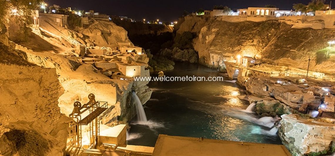
Shushtar is a city in Khuzestan province, southwest of Iran. It’s situated at the foot of Zagros Mountains, about 90 km north of Ahvaz. In most historical periods from Sassanid to Pahlavi, this city was the capital of Khuzestan province. Shushtar owes much of its fame to the Shushtar Historical Hydraulic System located there. This system has been registered in UNESCO’s list of World Cultural Heritage Sites in 2009, referred to “as a masterpiece of creative genius.” Shushtar Historical Hydraulic System, inscribed as a masterpiece of creative genius, can be traced back to Darius the Great in the 5th century B.C. It involved the creation of two main diversion canals on the river Kârun one of which, Gargar canal, is still in use providing water to the city of Shushtar via a series of tunnels that supply water to mills. It forms a spectacular cliff from which water cascades into a downstream basin. It then enters the plain situated south of the city where it has enabled the planting of orchards and farming over an area of 40,000 ha. known as Mianâb (Paradise). The property has an ensemble of remarkable sites including the Salâsel Castel, the operation centre of the entire hydraulic system, the tower where the water level is measured, damns, bridges, basins and mills. It bears witness to the know-how of the Elamites and Mesopotamians as well as more recent Nabatean expertise and Roman building influence. The Shushtar Historical Hydraulic System demonstrates outstanding universal value as in its present form, it dates from the 3rd century CE, probably on older bases from the 5th century BCE. It is complete, with numerous functions, and large-scale, making it exceptional. The Shushtar Historical Hydraulic System is a homogeneous hydraulic system, designed globally and completed in the 3rd century CE. It is
Shushtar is a city in Khuzestan province, southwest of Iran. It’s situated at the foot of Zagros Mountains, about 90 km north of Ahvaz. In most historical periods from Sassanid to Pahlavi, this city was the capital of Khuzestan province. Shushtar owes much of its fame to the Shushtar Historical Hydraulic System located there. This system has been registered in UNESCO’s list of World Cultural Heritage Sites in 2009, referred to “as a masterpiece of creative genius.”
Shushtar Historical Hydraulic System, inscribed as a masterpiece of creative genius, can be traced back to Darius the Great in the 5th century B.C. It involved the creation of two main diversion canals on the river Kârun one of which, Gargar canal, is still in use providing water to the city of Shushtar via a series of tunnels that supply water to mills. It forms a spectacular cliff from which water cascades into a downstream basin. It then enters the plain situated south of the city where it has enabled the planting of orchards and farming over an area of 40,000 ha. known as Mianâb (Paradise). The property has an ensemble of remarkable sites including the Salâsel Castel, the operation centre of the entire hydraulic system, the tower where the water level is measured, damns, bridges, basins and mills. It bears witness to the know-how of the Elamites and Mesopotamians as well as more recent Nabatean expertise and Roman building influence.
The Shushtar Historical Hydraulic System demonstrates outstanding universal value as in its present form, it dates from the 3rd century CE, probably on older bases from the 5th century BCE. It is complete, with numerous functions, and large-scale, making it exceptional. The Shushtar Historical Hydraulic System is a homogeneous hydraulic system, designed globally and completed in the 3rd century CE. It is as rich in its diversity of civil engineering structures and its constructions as in the diversity of its uses (urban water supply, mills, irrigation, river transport, and defensive system). The Shushtar Historical Hydraulic System testifies to the heritage and the synthesis of earlier Elamite and Mesopotamian knowhow; it was probably influenced by the Petra dam and tunnel and by Roman civil engineering. The Shushtar hydraulic system, in its ensemble and most particularly the Shâdorvân Grand Weir (bridge-dam), has been considered a Wonder of the World not only by the Persians but also by the Arab-Muslims at the peak of their civilization. The Gargar canal is a veritable artificial watercourse which made possible the construction of a new town and the irrigation of a vast plain, at the time semi-desert. The Shushtar Historical Hydraulic System sits in an urban and rural landscape specific to the expression of its value.
Criterion (i): The Shushtar Hydraulic System is testimony to a remarkably accomplished and early overall vision of the possibilities afforded by diversion canals and large weir-dams for land development. It was designed and completed in the 3rd century CE for sustainable operation and is still in use today. It is a unique and exceptional ensemble in terms of its technical diversity and its completeness that testifies to human creative genius. Criterion (ii): The Shushtar Historical Hydraulic System is a synthesis of diverse techniques brought together to form a remarkably complete and large-scale ensemble. It has benefited from the ancient expertise of the Elamites and Mesopotamians in canal irrigation, and then that of the Nabateans; Roman technicians also influenced its construction. Its many visitors marvelled at it and were in turn inspired. It testifies to the exchange of considerable influences in hydraulic engineering and its application throughout antiquity and the Islamic period under the various Iranian dynasties.
Shushtar is one of the oldest and most beautifully decorated tourist attractions in Iran. Shushtar’s water sculptures are one of the oldest places in history. I was excited to see such a system that was built with such an idea in ancient times. A relaxing and beautiful place.
Afsaneseylan
Criterion (v): Shushtar is a unique and exceptionally complete example of hydraulic techniques developed during ancient times to aid the occupation of semi-desert lands. By diverting a river flowing down the mountains, using large-scale civil engineering structures and the creation of canals, it made possible multiple uses for the water across a vast territory: urban water supply, agricultural irrigation, fish farming, mills, transport, defence system, etc. It testifies to a technical culture dating back eighteen centuries serving the sustainable development of a human society, in harmony with its natural and urban environment.
The integrity of the hydraulic footprint is good, but its functional integrity compared with the original model is only partial and reduced, notably for the dams; it remains good for irrigation and water supply. The authenticity of elements reduced to archaeological remains is certain, but has been affected by 20th century works and materials so far as the civil structures and sites still in use are concerned. Efforts directed to the restoration of attributes that demonstrate authenticity must be pursued. Management and protection requirements The components of the management plan are satisfactory, but they need to be improved in terms of the interpretation of the sites and the involvement of the local population.
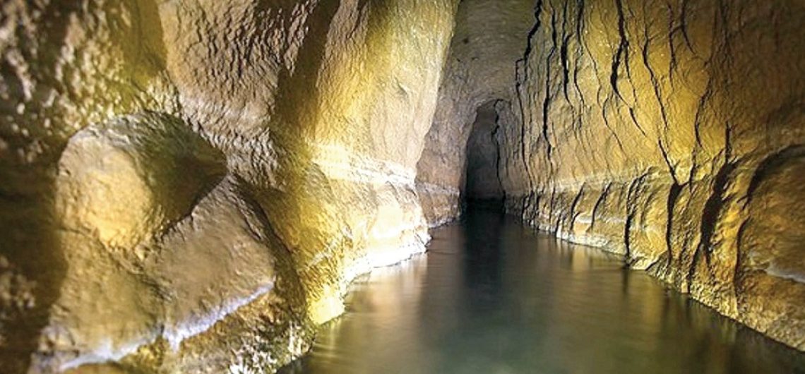
The Persian Qanat: Travel to the Mysterious Corridors Throughout the arid regions of Iran, agricultural and permanent settlements are supported by the ancient Persian Qanat system of tapping alluvial aquifers at the heads of valleys and conducting the water along underground tunnels by gravity, often over many kilometers. The eleven Qanats representing this system include rest areas for workers, water reservoirs and watermills. There is nothing strange about Qasabeh Qanat of Gonabad, and it may seem that the mystery of this place is a great joke that has brought many people from a distance. But with a little care we understand that what is before us is not just a simple Qanat, like many of the country's aqueducts, but also the largest, longest and oldest aqueduct of the world. An aqueduct with dark and black corridors that still provides water for the city, but nobody has ever come across. Nobody has any idea of the end of this aqueduct and its only length is 35 kilometers. The aqueducts with a depth of more than 300 meters showcased the blue masterpiece of the world since 2700 years ago. The Miracle of Persia: Persian Qanat Astonishingly, the structure of this aqueduct has caused its name to be registered by the Cultural Heritage Organization in 2000 with the number 2963 in the national list of Iran and at the Istanbul Summit on July 24, 1959 in the list of works registered at UNESCO. Persian Qanats provide exceptional testimony to cultural traditions and civilizations in desert areas with an arid climate. The Iranians rip the foothills in search of water, and when they find any, by means of Qanats they transfer this water to a distance of 50 or 60 kilometers or sometimes further downstream. No nation in the world can compete with the Iranians in
The Persian Qanat: Travel to the Mysterious Corridors
Throughout the arid regions of Iran, agricultural and permanent settlements are supported by the ancient Persian Qanat system of tapping alluvial aquifers at the heads of valleys and conducting the water along underground tunnels by gravity, often over many kilometers. The eleven Qanats representing this system include rest areas for workers, water reservoirs and watermills. There is nothing strange about Qasabeh Qanat of Gonabad, and it may seem that the mystery of this place is a great joke that has brought many people from a distance. But with a little care we understand that what is before us is not just a simple Qanat, like many of the country’s aqueducts, but also the largest, longest and oldest aqueduct of the world. An aqueduct with dark and black corridors that still provides water for the city, but nobody has ever come across. Nobody has any idea of the end of this aqueduct and its only length is 35 kilometers. The aqueducts with a depth of more than 300 meters showcased the blue masterpiece of the world since 2700 years ago.
The Miracle of Persia: Persian Qanat
Astonishingly, the structure of this aqueduct has caused its name to be registered by the Cultural Heritage Organization in 2000 with the number 2963 in the national list of Iran and at the Istanbul Summit on July 24, 1959 in the list of works registered at UNESCO.
Persian Qanats provide exceptional testimony to cultural traditions and civilizations in desert areas with an arid climate.
The Iranians rip the foothills in search of water, and when they find any, by means of Qanats they transfer this water to a distance of 50 or 60 kilometers or sometimes further downstream.
No nation in the world can compete with the Iranians in recovering and transferring groundwater. ‘ITwy make use of groundwater in irrigating their farmlands, and they construct qanats almost everywhere and always succeed in extracting groundwater.
Jean Chardin, 15th and 16th century
Enter to the Water Masterpiece of the World
To enter these corridors, you must trust the stairs and go down deep. The strange and mysterious world of the Persian Qanat brings the corridors of fear for you. The holes on the walls were once home to torch lamps and other lighting fixtures, and today they are falling asleep along the roots of the trees on the wall of the aqueduct. The color is black that looks very much here. The halls, which are only 40 percent available, are unclear what’s going on in 60 percent of the rest! The breeze that flow through the Qanat and the water sound that resonates with the uncovered mysteries of the aqueduct give us a new experience.
Perhaps the words to describe this amazing aquarium are low. The hallways dating back to 2,700 years old, and perhaps the reason why people say the construction of this aqueduct cannot be human work! Perhaps demons have come and made it here and gone!
The Mysteries of Qasabeh Qanat
Throughout Iran, wells and aqueducts have an important role in supplying the water needed by humans. But Qasabeh Qanat is much more intelligent than what you’ve ever seen. What’s in Gonabad is the clever appearance of the combination of wells and aqueducts, which are formed horizontally and vertically and preserved to this day. Two types of wells are dug in this amazing aqueduct. Some are shallow and vertical, and others are deep and steep.
Now imagine how in ancient times, with its limited and basic facilities, and with which calculations such accurate water flows from the depths of the earth to its surface? Perhaps there was a strange force in its makers! Maybe we’re a bit unfair and we’ve underestimated our human and intelligence!
This aqueduct is the most abundant aqueduct in the world, which feeds 150 liters per second.
Visiting Qasabeh Qanat is not just a visit to a Persian Qanat. The journey is a historic one that says its mysteries to you. In each part of the Qanat, intelligence can be seen that the Qanat makers create these corridors. Get good memories during to visit this aqueduct.
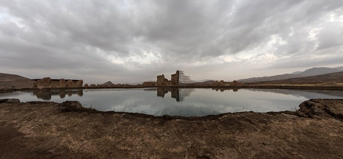
Takht-e Soleyman Located 45 km northeast of Takab, it is an ancient site that has been building holy structures around it since 1600 years ago. The fifth Bahram Vassan Sassanid built the site as a city and 70 years after it, Ghobad first expanded its buildings until it reached its peak at the time of Khosrow Anoshirvan Sassanid. The discovery of the signs and remnants of human presence from the first millennium BC to the 11th century AH in this 12-hectare area reveals the mysteries of the city to experts. For a long time, humans used this collection as a habitation, and religious beliefs about it illustrate the importance of the city throughout history. Takht-e Soleyman is believed to be the birthplace of Zoroaster, and the construction of Azargoshnasb Fire Temple in this area as the most respected Zoroastrian temple during the Sassanian period can be a confirmation of this belief. This temple was important in the socio-political life of the Sassanids, and its immortal flames were not extinguished for seven centuries, as a symbol of the authority of Zoroastrianism. Some people believe that the city has been the site of the holy grail of Christ, which he drinks on its last night of life. This cup is famous for the Grail Cup, but no trace of it has been seen on Takht-e Soleyman.The folk belief of this city is considered to be the location of Solomon's prophet, and points out that extraterrestrial forces, based on the orders of Hazrat Solomon, built massive structures that human beings cannot afford to create. This collection was registered in 1316 with the number 318 in the National Iranian Book List. The name of this work is also on the UNESCO World Heritage List. Takht-e Soleyman; A City Full of Treasure in the Depths
Takht-e Soleyman Located 45 km northeast of Takab, it is an ancient site that has been building holy structures around it since 1600 years ago. The fifth Bahram Vassan Sassanid built the site as a city and 70 years after it, Ghobad first expanded its buildings until it reached its peak at the time of Khosrow Anoshirvan Sassanid.
The discovery of the signs and remnants of human presence from the first millennium BC to the 11th century AH in this 12-hectare area reveals the mysteries of the city to experts. For a long time, humans used this collection as a habitation, and religious beliefs about it illustrate the importance of the city throughout history.
Takht-e Soleyman is believed to be the birthplace of Zoroaster, and the construction of Azargoshnasb Fire Temple in this area as the most respected Zoroastrian temple during the Sassanian period can be a confirmation of this belief. This temple was important in the socio-political life of the Sassanids, and its immortal flames were not extinguished for seven centuries, as a symbol of the authority of Zoroastrianism.
Some people believe that the city has been the site of the holy grail of Christ, which he drinks on its last night of life. This cup is famous for the Grail Cup, but no trace of it has been seen on Takht-e Soleyman. The folk belief of this city is considered to be the location of Solomon’s prophet, and points out that extraterrestrial forces, based on the orders of Hazrat Solomon, built massive structures that human beings cannot afford to create.
This collection was registered in 1316 with the number 318 in the National Iranian Book List. The name of this work is also on the UNESCO World Heritage List.
Takht-e Soleyman; A City Full of Treasure in the Depths of the Lake
The myths of this mysterious lake are not one in two. There are many stories in many language circles that reveal this phenomenon much more complex than a typical lake. The most famous legend is the existence of countless treasures in the depths of the lake. Endless treasures that have been thrown to the lake throughout history. Stories that have led many to the lake, but it should be noted that access to such treasures does not look so safe.
This legendary city (Takht-e Soleyman) underneath the lake contains many objects with signs of them. It is interesting to know that in none of the historical periods there is no finding of these treasures
Ring of Solomon the Prophet
The most controversial treasure that may exist on the lake floor is Solomon’s ring. According to folk beliefs, the whole collection of Takht-e Soleyman was made by super powers who Solomon commanded them. He had a ring that took all his power from it. There is a story telling that the Devil was able to reach the ring and put it into the lake to rely on the throne of Solomon. After this incident, Satan sat down on the throne of Solomon. Some believe that Suleiman the prophet never achieved this ring, but there are other interpretations that says that Solomon was able to remove the ring from the stomach of a fish that had eaten it and defeat Satan.
Treasure Search on Takht-e Soleyman
Efforts have been made to discover this treasure and answer the questions that are there, but the depth of the lake and its deposits are an important obstacle for explorers. It’s as if this treasure trove has a very strong bodyguard, so that nobody has been informed of its secret until this time. Even European explorers came to the lake, but no diving could penetrate more than 31 meters deep into the lake. Water pressure in the lake and heavy and heavy liquids are major obstacles to this.
For the first time, German divers came into the lake. According to their observations, which were later published, a lake was found at a depth of 112 meters. Also, 10 water channels were discovered on the edge of the lake, but due to their large water deposits and their limitation of vision, they could not discover a particular effect in the depths of the water.
Death, Gift of the Soleyman Lake
Around Takht-e Soleyman, there are several “Banned Swimming” themes, which can indicate that this beautiful lake is also equally scary. In addition to this tranquility, Takht-e Soleyman only serves the without experience guests with death; guests who like to lay their hands on the water of the lake, but do not report the anger within it. This lake brutally swallows every creature that enters it, deep down. Next to this lake, you can see the tomb of some of our compatriots who have gone to the lake and never returned. Of course, the lake returned only a corpse where it was buried there.
The site also has many important symbolic relationships, being associated with beliefs much older than Zoroastrianism as well as with significant biblical figures and legends.
Zendan-e Soleyman, a Place to Punish Rebellious Demon
An ancient volcano, known as Zendan-e-Soleyman (meaning ‘The Prison of Solomon’) is located about 3km to the west of the site. According to folk legend, this beautiful mountain area is known as Solomon’s Prison or Demon Prison, and they believe that Solomon had imprisoned the demons who disobeyed his command. This name has been placed on this mountain in accordance with the attribution of the site to Prophet Solomon.
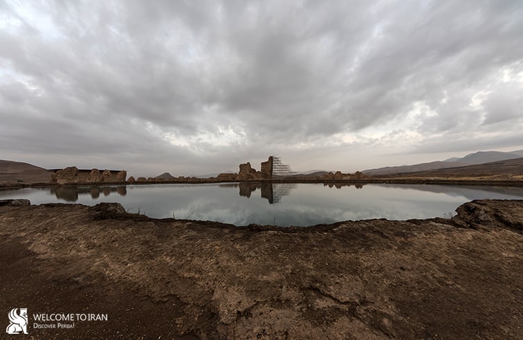
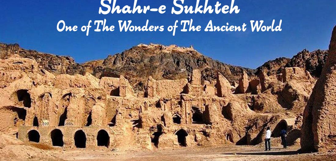
Shahr-e Sukhteh: One of the most advanced cities in the world Shahr-e Sukhteh, meaning ‘Burnt City’, is located at the junction of Bronze Age trade routes crossing the Iranian plateau. The remains of the mud brick city represent the emergence of the first complex societies in eastern Iran. Founded around 3200 BC, it was populated during four main periods up to 1800 BC, during which time there developed several distinct areas within the city: those where monuments were built, and separate quarters for housing, burial and manufacture. Diversions in water courses and climate change led to the eventual abandonment of the city in the early second millennium. The structures, burial grounds and large number of significant artifacts unearthed there, and their well-preserved state due to the dry desert climate, make this site a rich source of information regarding the emergence of complex societies and contacts between them in the third millennium BC. Shahr-e Sukhteh Shahr-e Sukhteh (Burnt City), one of the wonders of the ancient world, is a unique example of the first, the largest and the most advanced urban establishment of Bronze Age. Burnt City is located in eastern Iran and had been founded in the direction of Hirmand River to Hamun Lake. Changes in water courses and climate change led to the eventual abandonment of the city in the early second millennium. The structures, burial grounds and large number of significant artefacts unearthed there and their well-preserved state due to the dry desert climate make this site a rich source of information regarding the emergence of complex societies and contacts between them in the third millennium BCE. Shahr-e Sukhteh bears exceptional testimony to a peculiar civilization and cultural tradition that entertained trade and cultural relations with ancient sites and cultures on the Indus Plain, southern shores of the Persian Gulf, the Oman Sea and
Shahr-e Sukhteh: One of the most advanced cities in the world
Shahr-e Sukhteh, meaning ‘Burnt City’, is located at the junction of Bronze Age trade routes crossing the Iranian plateau. The remains of the mud brick city represent the emergence of the first complex societies in eastern Iran. Founded around 3200 BC, it was populated during four main periods up to 1800 BC, during which time there developed several distinct areas within the city: those where monuments were built, and separate quarters for housing, burial and manufacture. Diversions in water courses and climate change led to the eventual abandonment of the city in the early second millennium. The structures, burial grounds and large number of significant artifacts unearthed there, and their well-preserved state due to the dry desert climate, make this site a rich source of information regarding the emergence of complex societies and contacts between them in the third millennium BC.
Shahr-e Sukhteh
Shahr-e Sukhteh (Burnt City), one of the wonders of the ancient world, is a unique example of the first, the largest and the most advanced urban establishment of Bronze Age. Burnt City is located in eastern Iran and had been founded in the direction of Hirmand River to Hamun Lake.
Changes in water courses and climate change led to the eventual abandonment of the city in the early second millennium. The structures, burial grounds and large number of significant artefacts unearthed there and their well-preserved state due to the dry desert climate make this site a rich source of information regarding the emergence of complex societies and contacts between them in the third millennium BCE.
Shahr-e Sukhteh bears exceptional testimony to a peculiar civilization and cultural tradition that entertained trade and cultural relations with ancient sites and cultures on the Indus Plain, southern shores of the Persian Gulf, the Oman Sea and South-west Iran, and Central Asia. Archaeological remains and finds indicate the key role of the city on a very large scale in terms of working with metals, stone vessels, gems and pottery.
The ancient site of Shahr-e Sukhteh is an outstanding example of early urban planning: excavations have brought to light well-preserved evidence in the form of its mud-brick structures, burial grounds, workshops and artefacts that testify to its size, organisation, the source of its wealth and its trade and social structures. The city was separated into various parts according to different functions – residential, industrial and burial; it therefore represents an important stage in urban planning in the region.
Authenticity
In general the surrounding desert landscape and extraordinary scatter of archaeological material present on the surface of the low hill of Shahr-e Sukhteh give a strong sense of authenticity, as does the sight of the complex architecture of the various parts so far excavated. The labyrinthine succession of rooms, corridors and courtyards give a genuine impression of these ancient buildings.
Protection and Management Requirements
Shahr-e Sukhteh was registered in the list of national cultural properties of Iran as no. 542 in 1966. The property is further protected by a buffer and landscape zones where activities are regulated and subject to approval by the Iranian Cultural Heritage, Handicrafts and Tourism organisation (ICHHTO).
The archaeological excavations and finds have been documented since the 1970s and records, inventory and finds are stored and analysed at the ICHHTO multi-disciplinary Base at Shahr-e Sukhteh. The excavated remains are cleaned regularly during the year and Kahgel plaster is applied to conserve exposed walls.
The property is managed by the Iranian Cultural Heritage, Handicrafts and Tourism Organisation (ICHHTO) on behalf of the government of the Islamic Republic of Iran by ICHHTO’s Base at the property, located in the buffer zone, through a management plan that includes short, medium and long term activities concerning research, conservation, visitor management and presentation. The Base is advised by a steering committee comprising regional officials and experts and a technical committee comprising regional officials and experts. The Higher Education Centre of ICHHTO and national universities provide sources of expertise and training in conservation and management. The Research Organisation of Cultural Heritage and Tourism is responsible for multi-disciplinary research and training.
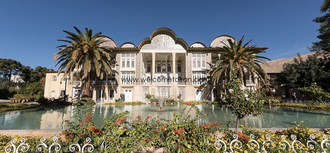
Eram Garden (Baq-e Eram), the Garden of Paradise, is one of the most famous and beautiful Persian gardens in all of Iran. It should be noted that the word ‘Eram’ is the Persian version of the Arabic word ‘Iram’ which means heaven in Islam’s holiest of books, the Qur’an. With its beautiful grounds, lush plant life and aesthetic attractions, it’s easy to see why Eram evokes such a description. Baq e Eram with their beautiful flowers, refreshing air, aromatic myrtles and towering cypress trees, including one tree which is said to date back to 3000 years ago (Sarv-e naz), the Eram Gardens are a major tourist destination, especially during the spring. History of Eram Garden Although no one is quite sure when construction of the gardens began, historical evidence suggests that the gardens were built during the Seljuk Dynasty (11th-14th centuries) under the rule of one of its most celebrated monarchs, Ahmad Sanjar. Like many other attractions in Shiraz, the Eram Gardens (Baq e Eram) have been restored and repaired by the Zand kings of the Zand Dynasty (1750-1794), but during the later period of the Zand Dynasty, the garden changed hands to a Qashgai tribal chief, Mohammad Qoli Khan. Mohammad Qoli Khan ordered the construction of the original mansion that stood on the grounds in the early 18th century, and planted various trees and plants in the garden including pine, orange, cypress and persimmon trees. Later on, during the rule of King Nasser ed-din of the Qajar Dynasty (1785-1925) Mirza Hassan Ali Khan Nasir-al Mulk bought the gardens from the Qashgai tribes and began construction on the present pavilion that now stands in the gardens. As noteworthy as the gardens themselves, the pavilion was constructed by a local Shirazi architect, one Mohammad Hassan. The beautiful three-story structure was constructed
Eram Garden (Baq-e Eram), the Garden of Paradise, is one of the most famous and beautiful Persian gardens in all of Iran. It should be noted that the word ‘Eram’ is the Persian version of the Arabic word ‘Iram’ which means heaven in Islam’s holiest of books, the Qur’an. With its beautiful grounds, lush plant life and aesthetic attractions, it’s easy to see why Eram evokes such a description.
Baq e Eram with their beautiful flowers, refreshing air, aromatic myrtles and towering cypress trees, including one tree which is said to date back to 3000 years ago (Sarv-e naz), the Eram Gardens are a major tourist destination, especially during the spring.
History of Eram Garden
Although no one is quite sure when construction of the gardens began, historical evidence suggests that the gardens were built during the Seljuk Dynasty (11th-14th centuries) under the rule of one of its most celebrated monarchs, Ahmad Sanjar. Like many other attractions in Shiraz, the Eram Gardens (Baq e Eram) have been restored and repaired by the Zand kings of the Zand Dynasty (1750-1794), but during the later period of the Zand Dynasty, the garden changed hands to a Qashgai tribal chief, Mohammad Qoli Khan.
Mohammad Qoli Khan ordered the construction of the original mansion that stood on the grounds in the early 18th century, and planted various trees and plants in the garden including pine, orange, cypress and persimmon trees. Later on, during the rule of King Nasser ed-din of the Qajar Dynasty (1785-1925) Mirza Hassan Ali Khan Nasir-al Mulk bought the gardens from the Qashgai tribes and began construction on the present pavilion that now stands in the gardens.
As noteworthy as the gardens themselves, the pavilion was constructed by a local Shirazi architect, one Mohammad Hassan. The beautiful three-story structure was constructed based on the Safavid and Qajar styles of architecture, and includes tiles inscribed with poems from the famed Persian poet Hafez.
Architecture Styles of Eram Garden
The tradition and style of Baq e Eram design represented by Persian gardens or Iranian gardens has influenced the design of gardens from Andalusia to India and beyond. The gardens of the Alhambra show the influence of Persian garden philosophy and style in a Moorish palace scale, from the era of Al-Andalus in Spain. Humayun’s Tomb and Taj Mahal have some of the largest Persian gardens in the world, from the era of the Mughal Empire in India.
Today, Eram Garden (Baq e Eram) and building are within Shiraz Botanical Garden (established 1983) of Shiraz University. They are open to the public as a historic landscape garden. They are World Heritage Site, and protected by Iran’s Cultural Heritage Organization.
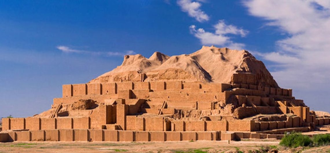
The Greatest Ziggurat In The World: Tchogha Zanbil Tchogha Zanbil is an ancient Elamite Complex in the Khuzestan province of Iran. It is one of the few existence Ziggurats outside of Mesopotamia. The ruins of the holy city of the Kingdom of Elam, surrounded by three huge concentric walls, are found at Tchogha Zanbil. Founded c. 1250 B.C. The city remained unfinished after it was invaded by Ashurbanipal, as shown by the thousands of unused bricks left at the site. What is Ziggurat? The ziggurat is the most distinctive architectural invention of the Ancient Near East. Like an ancient Egyptian pyramid, an ancient Near Eastern ziggurat has four sides and rises up to the realm of the gods. However, unlike Egyptian pyramids, the exterior of Ziggurats were not smooth but tiered to accommodate the work which took place at the structure as well as the administrative oversight and religious rituals essential to Ancient Near Eastern cities. Ziggurats are found scattered around what is today Iraq and Iran, and stand as an imposing testament to the power and skill of the ancient culture that produced them. Outstanding Universal Value Tchogha Zanbil is located in ancient Elam (today Khuzestan province in southwest Iran), Tchogha Zanbil (Dur-Untash, or City of Untash, in Elamite) was founded by the Elamite king Untash-Napirisha (1275-1240 BCE) as the religious center of Elam. The principal element of this complex is an enormous Ziggurat dedicated to the Elamite divinities Inshushinak and Napirisha (Inshushinak was one of the major gods of the Elamites and the protector deity of Susa, the ziggurat at Tchoqa Zanbil is dedicated to him). It is the largest Ziggurat outside of Mesopotamia and the best preserved of this type of stepped pyramidal monument. The archaeological site of Tchogha Zanbil is an exceptional expression of the culture, beliefs, and ritual
The Greatest Ziggurat In The World: Tchogha Zanbil
Tchogha Zanbil is an ancient Elamite Complex in the Khuzestan province of Iran. It is one of the few existence Ziggurats outside of Mesopotamia. The ruins of the holy city of the Kingdom of Elam, surrounded by three huge concentric walls, are found at Tchogha Zanbil. Founded c. 1250 B.C. The city remained unfinished after it was invaded by Ashurbanipal, as shown by the thousands of unused bricks left at the site.
What is Ziggurat?
The ziggurat is the most distinctive architectural invention of the Ancient Near East. Like an ancient Egyptian pyramid, an ancient Near Eastern ziggurat has four sides and rises up to the realm of the gods. However, unlike Egyptian pyramids, the exterior of Ziggurats were not smooth but tiered to accommodate the work which took place at the structure as well as the administrative oversight and religious rituals essential to Ancient Near Eastern cities. Ziggurats are found scattered around what is today Iraq and Iran, and stand as an imposing testament to the power and skill of the ancient culture that produced them.
Outstanding Universal Value
Tchogha Zanbil is located in ancient Elam (today Khuzestan province in southwest Iran), Tchogha Zanbil (Dur-Untash, or City of Untash, in Elamite) was founded by the Elamite king Untash-Napirisha (1275-1240 BCE) as the religious center of Elam. The principal element of this complex is an enormous Ziggurat dedicated to the Elamite divinities Inshushinak and Napirisha (Inshushinak was one of the major gods of the Elamites and the protector deity of Susa, the ziggurat at Tchoqa Zanbil is dedicated to him). It is the largest Ziggurat outside of Mesopotamia and the best preserved of this type of stepped pyramidal monument. The archaeological site of Tchogha Zanbil is an exceptional expression of the culture, beliefs, and ritual traditions of one of the oldest indigenous peoples of Iran. Our knowledge of the architectural development of the middle Elamite period (1400-1100 BCE) comes from the ruins of Tchogha Zanbil and of the capital city of Susa 38 km to the north-west of the temple).
The archaeological site of Tchogha Zanbil covers a vast, arid plateau overlooking the rich valley of the river Ab-e Diz and its forests. A “sacred city” for the king’s residence, it was never completed and only a few priests lived there until it was destroyed by the Assyrian king Ashurbanipal about 640 BCE. The complex was protected by three concentric enclosure walls: an outer wall about 4 km in circumference enclosing a vast complex of residences and the royal quarter, where three monumental palaces have been unearthed (one is considered a tomb-palace that covers the remains of underground baked-brick structures containing the burials of the royal family); a second wall protecting the temples (Temenus); and the innermost wall enclosing the focal point of the ensemble, the ziggurat.
Tchogha Zanbil originally measured 105.2 m on each side and about 53 m in height, in five levels, and was crowned with a temple. Mud brick was the basic material of the whole ensemble. The ziggurat was given a facing of baked bricks, a number of which have cuneiform characters giving the names of deities in the Elamite and Akkadian languages. Though the ziggurat now stands only 24.75 m high, less than half its estimated original height, its state of preservation is unsurpassed. Studies of the ziggurat and the rest of the archaeological site of Tchogha Zanbil containing other temples, residences, tomb-palaces, and water reservoirs have made an important contribution to our knowledge about the architecture of this period of the Elamites, whose ancient culture persisted into the emerging Achaemenid (First Persian) Empire, which changed the face of the civilized world at that time.
The ruins of Susa and of Tchogha Zanbil are the sole testimonies to the architectural development of the middle Elamite period (1400-1100 BCE). The ziggurat at Tchogha Zanbil remains to this day the best-preserved monument of this type and the largest outside of Mesopotamia.
Authenticity
The historical monuments of the archaeological site of Tchogha Zanbil are authentic in terms of their forms and design, materials and substance, and locations and setting. Several conservation measures have been undertaken since the original excavations of the site between 1946 and 1962, but they have not usually disturbed its historical authenticity.
Protection of Tchogha Zanbil
Tchogha Zanbil was registered in the national list of Iranian monuments as item no. 895 on 26 January 1970. Relevant national laws and regulations concerning the property include the National Heritage Protection Law (1930, updated 1998) and the 1980 Legal bill on preventing clandestine diggings and illegal excavations. The inscribed World Heritage property, which is owned by the Government of Iran, and its buffer zone are administered by the Iranian Cultural Heritage, Handicrafts and Tourism Organization (which is administered and funded by the Government of Iran). A Management Plan was prepared in 2003 and has since been implemented. Planning for tourism management, landscaping, and emergency evacuation for the property has been accomplished and implementation was in progress in 2013. A research center has undertaken daily, monthly, and annual monitoring of the property since 1998. Financial resources for Tchogha Zanbil are provided through national budgets.
Conservation activities have been undertaken within a general framework, including development of scientific research programs; comprehensive conservation of the property and its natural-historical context; expansion of the conservation program to the surrounding environment; concentration on engaging the public and governmental organizations and agencies; and according special attention to programs for training and presentation (with the aim of developing cultural tourism) based on sustainable development. Objectives include research programs and promotion of a conservation management culture; scientific and comprehensive conservation of the property and surrounding area; and development of training and introductory programmers.
Sustaining the Outstanding Universal Value of the property over time will require creating a transparent and regular funding system, employing efficient and sustainable management systems, supporting continuous protection and presentation, enjoying the public support and giving life to the property, adopting a “minimum intervention” approach, and respecting the integrity and authenticity of the property and its surrounding environment. In addition, any outstanding recommendations of past expert missions to the property should be addressed.