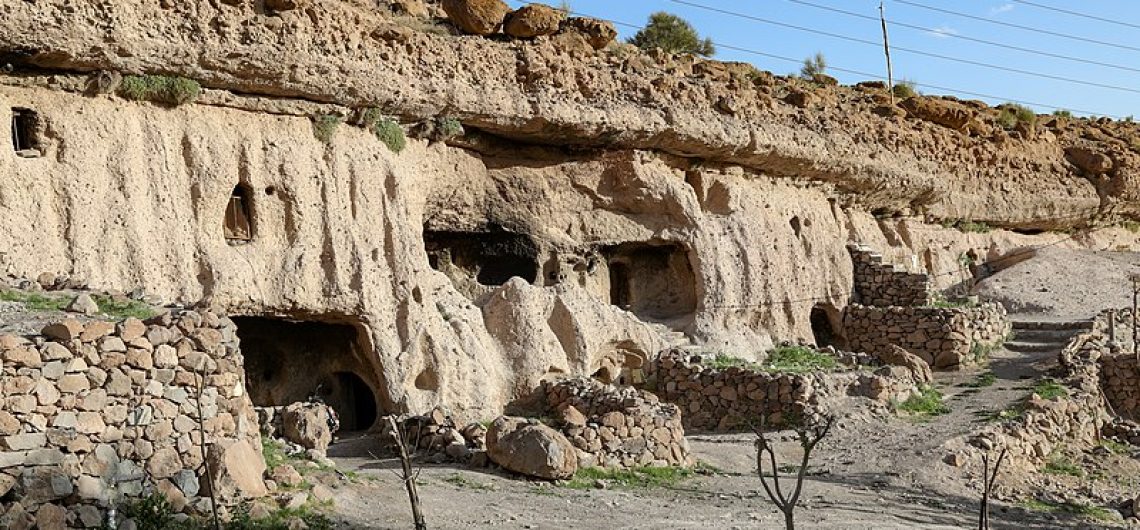
Maymand is a self-contained, semi-arid area at the end of a valley at the southern extremity of Iran’s central mountains. The villagers are semi-nomadic agro-pastoralists. They raise their animals on mountain pastures, living in temporary settlements in spring and autumn. During the winter months they live lower down the valley in cave dwellings carved out of the soft rock (kamar), an unusual form of housing in a dry, desert environment.  This cultural landscape is an example of a system that appears to have been more widespread in the past and involves the movement of people rather than animals.

Outstanding Universal Value of Meymand

Brief Synthesis

Maymand is a small and relatively self-contained south facing valley within the arid chain of Iran’s central mountains. The villagers are agro-pastoralists who practice a highly specific three phase regional variation of transhumance that reflects the dry desert environment. During the year, farmers move with their animals to defined settlements, traditionally four, and more recently three, that include fortified cave dwellings for the winter months. In three of these settlements the houses are temporary, while in the fourth, the troglodytic houses are permanent.

Sar-e-Āghol are the settlements on the southern fields used from the end of winter until late spring. The houses come in two different types. Markhāneh are circular houses, semi-underground to shelter them from the wind, with low dry stone wall and a roof covering of wood and thatch of wild thistles. Mashkdān houses are above ground and built with dry stone walls and a conical roof of branches. Some of the buildings for cattle are much more substantial and have barrel vaulted brick or stone roofs.

Sar-e-Bāgh houses are sited near seasonal rivers and used during summer and early autumn. When the weather is hot the structures are light: dry stone walls support a roof structure of vertical and horizontal timbers covered with grass thatch. In inclement weather more substantial houses are constructed with taller stone walls and a conical roof. Cattle are collected in roofless stone enclosures. Around these summer villages are the remains of terraces for growing wheat and barley, and the remains of mostly now ruined water-mills. Pits for boiling and straining grape juice are still in use as are Kel-e-Dūshāb which are used to contain the resulting Dūshāb or syrup of grapes.

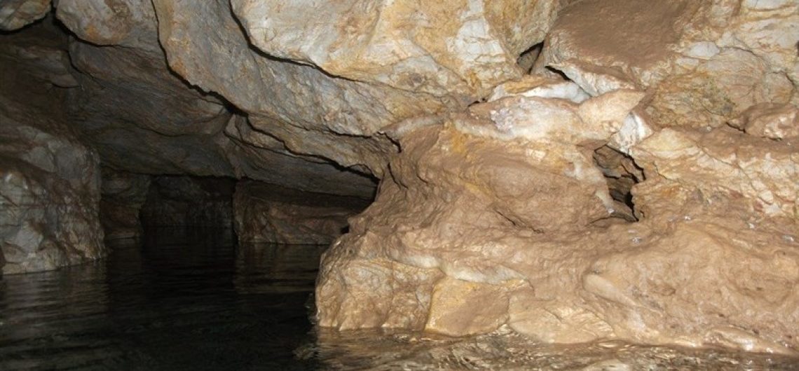
The winter troglodytic houses are carved out of the soft rock, in layers of up to five houses in height. Around 400 Kiches or houses have been identified and 123 units are intact. Each house has between one and seven rooms, traditionally used for living, and storage.

In the exceptionally arid climate, traditionally every drop of water needed to be collected from a variety of sources such as rivers, springs and subterranean pools and collected in reservoirs or channelled through underground qanats to be used for animals, orchards and small vegetable plots. The community has a strong bond with the natural environment that is expressed in social practices, cultural ceremonies and religious beliefs.

Criterion (v): The Cultural Landscape of Maymand, a small mainly self-sufficient community within one large valley, reflects a traditional three phase transhumance system with unusual troglodytic winter housing in a dry desert environment. It is a good example of a system that appears to have been once more widespread, and involves the movement of people rather than animals to three defined settlement areas, one of which is cave dwellings.

Integrity

All the components of the landscape reflecting the agro-pastoral system and permanent and seasonal dwellings are within the boundaries. The components are however vulnerable, in relation to the resilience of the transhumance systems. This continues for the present, with a decreasing population. Although the small irrigated fields survive in outline they no longer are used to grow staple crops for self-sufficient families.

Improved communications, such as with nearby towns means that people can look after their animals and vegetable plots in different ways than previously. As a result far fewer people are over-wintering in the troglodytic villages than a generation ago and there are far fewer families using the seasonal settlements.  Only around 90 out of 400 of the troglodytic dwellings are inhabited during the winter. A few more of them are inhabited only during weekends, when people return from the nearest town to where they have moved.

The number of Āghols has reduced in the last few years due to the decreasing numbers of pastoralists. In the property there remain at least 8 Āghols that are still living and used by families who have sufficient cattle to ensure their survival. There are two others that are abandoned. Most of the seasonal buildings are largely re-constructed each season and are therefore a reflection of a traditional practice that has persisted for generations. But this is a practice that is highly vulnerable and could disappear within a generation, if the pastoral way of life is not attractive or sufficiently viable for the younger generation.

Authenticity

There is little doubt of the authenticity of most of the components of the property, in terms of the landscape itself and the traditional practices that interact with it, as reflected in troglodytic houses, seasonal shelters and water structures. Some of the latter have been adapted in recent decades and only two of the qanats survive. The troglodytic structures have undergone extensive restoration over the past ten years.

Authenticity is also vulnerable to a weakening of traditional practices which could lead to a reduction in the size of the community that manages the landscape, to more families only living in the valley during the summer months, and to the impacts of tourism in particular on the troglodytic dwellings.

Protection and Management Requirements

The troglodyte village is registered in the National Heritage List, and is protected under the Historical Monument’s Protection and Conservation Law. It is understood that the whole property will be legally protected upon inscription in line with other inscribed properties in Iran.

The property is also protected by other cultural and natural Iranian laws, such as the Iranian Civil Law that forbids transferring the ownership of public monuments and prohibits private ownership of significant cultural property. The Islamic Penal Law also protects the property, as no restoration, repair, renovation, transfer, or change of functions, etc. of registered monuments can be done without the Iranian Cultural Heritage, Handicrafts and Tourism Organization approval. The area is also under regulation concerning natural heritage protecting the natural environment.

Since 2001 the Iranian Cultural Heritage, Handicrafts and Tourism Organization has assumed responsibility for the property and a Maymand Cultural Heritage Base has been established, with close links to the Maymand village council and the Maymand village administration office. The local council manages the day-to-day affairs in collaboration with the Maymand Cultural Heritage Base. There are currently adequate local resources for administration

A Management Plan in the initial nomination set out regulations for the property area. For the buffer zone, large scale plans that may include industrial complexes and development projects such as highways, etc. must be agreed by the Iranian Cultural Heritage and Tourism Organisation.

Details of an augmented plan, arising from a workshop that aimed to encourage sustainable development for the local communities by opening up engagement between them and national and regional agencies, have been provided. This will focus on raising awareness of the legacy that the communities sustain, and put in place a sustainable development framework based on support and encouragement for innovative ways to add value to local produce, as well as some official support such as for dredging qanats and vaccinating livestock. This sustainable development plan has only recently been framed and clearly more work will be needed to translate it into an action plan with an agreed timescale and necessary resources.

Three other plans have also been developed by University Departments. These are: Evaluation of Ecological Capabilities, Agro-Pastoral lifestyle description and comparative study, and Research project on the impact of Water Sources and Farming. In addition a local team is engaged in mapping the activities of the farming year.

In spite of these initiatives and the engagement of the local community in a dialogue on how to sustain the dynamic landscape practices, there is nevertheless still concern that such a small community of some 70 families can form a sustainable and resilient unit that will keep the Maymand agro-pastoral system alive, even if in the future it does not survive in neighbouring valleys. Authenticity and integrity are thus vulnerable to a weakening of traditional practices.

Sustainable development will undoubtedly need to harness appropriate tourism opportunities. A plan is needed to set out how tourism might be managed in such a way that it supports rather than detracts from local traditions and avoids turning the village into a museum and contributing to the demise of agro-pastoral traditions.

References:

  1. Maymand – http://whc.unesco.org/en/list/1423

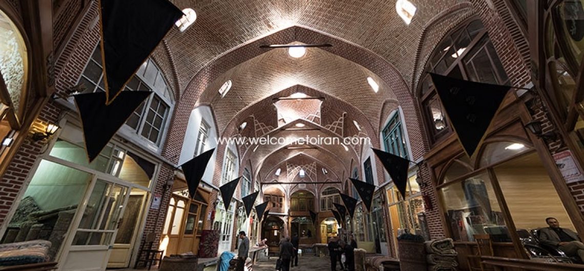
Tabriz Grand Bazaar is one of the most important and largest roofed markets of whole Iran and world that is located in the Tabriz city of Iran.

This market has about the area of one square kilometer and that is one of the biggest covered markets in the whole world.

This market contains variety Market, Corridor, Timche, Serra, and Caravanserai. Mostly because Tabriz city located in the place of The Silk Road Crossroads and every day about thousands of Caravans from different Asian, African and European countries passing this way so this city and its markets have very well boomed.

Tabriz Grand Bazaar rebuilding by time ruler of Tabriz about 3 century ago and after historical Earth quack occurrence in the year 1193.

This market is registered in National Iranian Book List in the date of 1975. It is not clear when this beautiful historical place was built but some of the old tourists that they visited this place until the Qajar period gave good and useful information about this market.

tabriz-grand-bazaar-1

Some of the tourists such as follow admired this old beautiful market:

  • Ibn Battuta
  • Marco Polo
  • Jackson
  • Oliya Chalabi
  • Yaquot Hamavi
  • Gaspar Derville
  • Alexis Soketov
  • Jean Sharden
  • Ouzhen Felanden
  • John Cartwright
  • Jamli Cardi
  • Clavikho
  • Robert Grant Watson
  • Hamdollah Mostofi
  • Moghadasi

Tabriz Grand Bazaar known with containing about 5500 shops, about 40 different kinds of jobs, 35 series of shops, 25 small shops, 30 mosques, 20 parts of sides of the market, 11 corridors, 5 bathrooms and 12 schools is one of the main central parts of trading in Tabriz city and whole Iran.

tabriz-grand-bazaar-2

Trades in Tabriz Grand Bazaar

English Traders carried their materials to the Silk Road many years ago and there was the place of trading for them.

Tabriz was the main place of business for the European countries many years ago by the North ways. This city had about 25-33 percent of trading of Whole Iran on its hands in the year of 1877. In the year of 1906 Tabriz was the main place of trading of Iran with the middle Asia.

European people enter many materials such as Mirror, All kinds of silk fabrics, Velvet and cotton, sugar, glass, metal and mechanical products to Tabriz market.

This market sold many things to European people either but always these trading have lots of benefits for them.

tabriz-grand-bazaar-3

Lut plains or Lut desert is the wilderness plain in the southeast of Iran. This plain with more than 40000 square kilometers area (contains both arena and privacy) is located in between some parts of Kerman, Sistan and Baluchistan and south Khorasan and with the area about 175000 Kilometers and has about 10 percent of the extent of Iran.

Lut desert is the 25th biggest desert of the whole world.

Lut desert is one of the regions that is ultra hot and dry. The core of that in the (2004, 2005, 2006, 2007, 2009)  years showed this desert as the hottest point of the world that the most of them recorded in the year 2005 with the maximum temperature of 70. 7 ° C. Scientifics know the reason of the high temperature of this place is because of the dark colour and the dryness of the surface of that, and they are the reason of the absorption of the sunlight by the surface of the earth. Lout desert is from the north- west to the south- east. The length of that is 320 Kilometers (200 Miles) and the width of that is 160 Kilometers (100 Miles).

Name of Lut Desert

Lut means naked and without anything. Desert is the ecological and climate word that the vegetation, life, and downpours are very low there, but salt marsh is the lowest inner parts of the desert, it means that the place that it has lots of salt inside itself. In the global registration file Lout in UNESCO the title of “Lout desert ”  is registered not the “Lout Saltmarsh” because this plain is a desert and not the salt marsh and the salt marsh is only formed the small part of the Lout plain area. In the geographical writings of the Lout sometimes it is called “ Lout Pits”(Chaleh Lout), Sometimes it has the shape of “ Lot plain” and near the common people because of some similarities with the desert plain it has often the name of “Lout Desert”. “Lout Plain”  is in the shape of the vast sandy desert. There are pits or several local watersheds that each of them receives around batch surface runoff. In the “Lout plain” the desert areas are usually emerged in inside or around these watersheds (Local pits) or in the parts of the seasonal and temporary streams.

Generally the salt marsh area in the “Lout plain” is not too much in compare with the sandy earth or in the other words it is not too much important that it can effect on the natural landscape of the place. From this point “Lout plain” is right in front of the “Salt marsh – plain” and most of its area are contains by the “salt marsh”.

So as researchers have emphasized repeatedly in their Geography writings using the “Lout Saltmarsh” in this unit is not correct and the people must use the words such as: “Lout plain” and “Lout desert” instead.

The Hottest point of the Earth

Based on measurements from World Meteorological Organization the highest recorded temperature on Earth belonging to the Aziziya Libya weather station that is located in the Sahara, that the temperature of that in the 13th September of 1992 in this station registered (58 °C )(136,4 Fahrenheit degree). Before that, the record of the hottest spot in the world belonged to “Death Valley” in California that was measured (56. 7 ° C) in the year 1913. In study of the warmest parts of the Earth by using the satellite images of Medic sensor from the years 2003 – 2009 by NASA , Lout desert in the years of 2004,2005,2006,2007,2009 measured as the hottest point of the world that in the year 2005 with the temperature of 70,7 °C  recorded the hottest temperature in all the Earth. This temperature is 12 ° C higher than the official record of the Earth’s temperature that has been recorded in 1992 in Libya. People must pay attention that the hottest points of the world will change in the various years, in addition, the Earth’s surface temperature is usually higher than the air temperature at the same point and the recorded number as the Earth’s surface temperature that is coming from the surface temperature index is not mean the air temperature of the areas. The study of the scientists about the difference between air temperature and ground in Death Valley in 1915 showed in the way that when the temperature of the surface of Earth in the depth of  0,4 centimeters of the surface dust is 71,5 °C the temperature of the weather in the 120 centimeters of the surface of the Earth is about 42,5 °C.

In many of the Iranian and abroad medias base on the speech of the Doctor Parviz Kordavani the region of the “Gandom Berian” (in the 80 Kilometers of north of Shahdad) is called as the hottest point of the Lout and world but Kordavani by rejecting this claim believe that the hottest point of the earth is located in the “Lout desert” in the “central Lout pit” in the 75 Kilometers of the east of Shahdad and knowing “Gandom Berian” as the hottest point of the world is not correct.

Position and general indicates of the “Lut plain”

  • Lout plain is the range in between the south Khorasan, Sistan and Baluchestan and Kerman provinces.
  • Lout plain is located in between the two faults of Nahbandan in east and Naay band (epiglottis) in the west.
  • Its northern limit is in the circuit of 32 degrees and its southern limit is in the circuit of 28 degrees.
  • The extent of the “Lout plain” basin, is about 175000 Square Kilometers one-tenth of the area of the country.
  • The length of that from north to south is about 900 Kilometers and from the west to east, it is about 300 Kilometers.
  • The lowest point of the “Lout plain” is about 190 meters lower than the surface of the sea.(Central Lout)
  • Lout plain was the place of big and important earthquakes.
  • In the foot of Mount, that they are in front of the big “Lout saltmarsh” some signs of residence of people that they were related to the fourth millennium B.C. were found.
  • The largest population area of “Lout plain” is “Shahdad” that it was called in the past with the name of “Khabis”.
  • Sirach valley and the residential area of that with the same name is one of the most beautiful green landscapes in the margin of this mysterious plain.

Interesting phenomena

Lut plain is one of the most interesting desert tolls of the whole world. Some of its attractions are as follow:

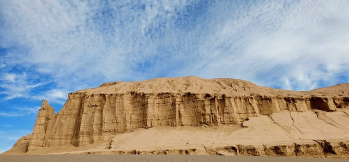
  • It is the biggest Clod city of the world. Kaluts area from the far is as same as the ruins of the great city that they are many descriptions about that such as: Imaginary city or town of
  • The highest sandy pyramids of the whole world is in the Lout. The highest known pyramids of the world maximum has 300 meters height (Libya) but in the Lout the height of the some of the pyramids even are sometimes 480 meters.
  • 40 Quaternary volcanic cones are located in the surface of the “Lout plain”.
  • Large areas of sand with the range of light brown to gray and black color such as “Godar Barout” (Gunpowder Godard) that because of that the dust of that is black and as same as the Gunpowder has this name.
  • The plains of basaltic lavas pitted and it is as same as the “Gandfom Berian”.
  • Wavy sandy areas.
  • The biggest Nabkas of the whole world are the sandy dunes that they covered with plants that is one of the wonders of the coexistence of soil and water and plants. Nakba call “Desert Vase” either.
  • The highest Rebdou(Rebdou is as same as the Nabka but in the largest dimensions and complex forms that they are located in the West Lout).
  • Zones in the shapes of numerous polygons that they are resulting of the thick layer of salt and high evaporation of surface.
  • “Pa shotory Saltmarsh” (Camel Leg Saltmarsh) the surface of these lands are in the shape that it seems after lots of raining the land come to be soak and many camels are walking on them.
  • Hammada are sandy plains that they contain no plant.

Geographical Units     

Lut plain is divided into three geographical Units:

  1. North Lout is formation from the different elements such as sand and the southern limit of that formed from the irregular cuts overlooking the pits, “Passion river of Birjand”. Irregular sand terrain that the tables of sand are inside them.
  2. Central Lout is the most admired part of the Lout plain. In the east parts of the central Lout there are located hills, and huge masses sandy interlocking of the sand and covered a significant level of Lout to an average width of 52 km and the average length of 162 km at there. Some parts of the irregularities of central Lout has been vegetation and the west part of that has no vegetation .

From the geomorphology the central Lout is divided into the three main regions (From the west to east):

1/Pediment with the width of  5-10 KL in the shapes of strips that the surface of it covered from the sand, silt and salt.

2/Kalutes

Kalut (the local expression ) are known as the gigantic gullies that they are result of water and wind erosion and they are known as the unrivaled phenomenon of the world.

The “passion river” has enough effect in making the walls of the Kalut in the moisturize shape and facilitated their erosions.

The Kalut region is located  in the 43 KL distance from the Shahdad (24 KL of the Seif village) and they formed in the area with the medium width of 80 KL and medium length of 145 KL.

The most important wind that erosion the walls of the Kalut are 120 days winds of  Sistan.

In the distance of the Kalut the earth is covered with the sand and in the placers that the earth doesn’t have sand the earth is covered with pad clay and clay.

3/Sandy hills in the east of the central Lout the region made with the width of 50 KL and length of 100 KL. The height of  these sandy hills are arrive to the 500 meters.

Sandy roughs have different shapes that you can watch them as follow:

  • Barkhan
  • Sandy pyramids
  • Sif
  • Lengthy hills

South Lut (Negro Lout) is the richest part of the Lout base on the vegetation.

Vegetation

In about 20 KL of Shahdad, Tamarisk shrubs, trees are located in the Lout dessert pot that the people said Nabka with the plant hills to them.

The earth in between the Nabkas are full of sand and they are generally appear in the flat surface that the range of the sand are medium there and the range of the mineral water are high or the humidity be ok for growing the life vegetation on them.

The elements that they are constituent the Nabka are containing as follow:

  • Sand – Silt
  • Clay
  • Celts

The shapes of Nabka contain the function of size, density and the amount of plant growth that there are contain as the other kinds such as: batch of Gramineae, Haloxylon Shrub, Tamarisk, …

In the Lout dessert the kind of Tamarix plant is from the host species of Nabka. The height of Nabka is from some decimeter to some meters and the length of them is from one meter to Ten meters.

Pay attention that the single plants must have the height more than 10-15 centimeters until they can control the sand.

If the sand don’t have cohesion mood in the other word they don’t have clay and silt elements the volume of them will change with the change and speed of the wind.

With increase the amount of sediment, the plant to avoid from buried continue its growing upward until the time that the root of the plant has its connection with the mineral water but in the place that the mineral water drop the connection will be cut and the destroying of the Nabka will be start that at the end the Nabka will be destroy and die.  The permanent and several years Nabka has the fundamental role of the region as follow:

  • Changes the level of underground water
  • Runoff
  • Evaporation
  • Transpiration
  • Wind sediment control

Rebdou with the bigger dimension are come to be apart from the Nabka. The length of them are come to be 2-7 meters and the width of them are 1-5 meters. Apart from the dimension, shape of  Rebdou are more complicated than Nabka ; and sometimes they show some cones that they are located near each other.

The highest Rebdou located in the west Lout that sometimes the height of them are arrive to the 12 meters(The height of one building with four floors).

Archaeological excavations

The Geographical Institute of Tehran University from the year of 1346 was starting studies about the Lout plain. The result of these researches leads to discover some objects as follow:

  • Examples of earthenware objects
  • Examples of metal objects
  • Examples of stone objects

All these objects are related to the pre-history time of this area, but this board because of being busy with its works of itself and don’t have the Archaeologist persons, failed in speculation and further investigation. Dasht-e Lut (Lout plain) board of studies in collaboration with the department of archeology in the year of 1347 went to this region and they can discover the various potteries pieces and with searching in the short hills and different ways that they are locating in between the different parts of Kalut they can arrive to the tombs of the pre- history time and the valuable objects of them.

Discovered Objects and Tombs

In the ten days searching of Aqous Shahdad that is located in the 7 KL distance of the Lout plain, various objects that they were belonging to the third millennium and the earthenware that they were for the fourth millennium of the pre-history found in the discovered tombs that they were containing the earthen dishes with the red colour that they were decorated with the different designs that they are in the part of design and shape and the way of doing as same as the discovered dishes that they were located in the Balampour of Balouchistan and Khourab of Kerman. Also there were discovered earthenware jug with the pea colour that was very delicate  that it had three red stripes on itself. Between these strips are filled with pictures of Eagle with the spread wings and they were decorated with parallel broken lines with the black colour. As same as this kind of dish were find in the Iran-Pakistan border in the hill with the name of the Koli Mahy (Gypsy Fish) that the age of them back to the third millennium B.C. and they can also compare with the colorful dishes of Susa.

Stony dishes

In the discovered tombs some kinds of Marble dishes and gray limestone were discovering. The Marble , colorful dishes of this region with the Marble objects of Susa that they belonged to the third millennium B.C. have the overall similarity. Discovering these kinds of objects in this place prove the relation of the Qabus nation with the far points. Also decorative and metal dishes were finding in this place.

Khour dessert

Khour dessert or Khour salt lake and Biabanak (small dessert) is a large area that is located in the margin of the Lout plain in the way of Isfahan to Tabas.  In the summer with dry the water the beautiful scenic of salt is creating that it has the shape as same as the shape of the North Pole and the area rich in snow.

Registered on UNESCO World Heritage List

Before the fortieth session of the World Heritage in Istanbul, Iran had 19 registered effects in the World Heritage that all of them were in the list of cultural Iran works and there were no natural effect in the list of World Heritage. In this session, the Lout dessert was registering as the first Natural effect of Iran in the UNESCO World Heritage List. Iran sent the file of Lout dessert and Iranian aqueduct for registering in the world Heritage list. First eleven aqueduct and after that the Lout dessert was included in the World Heritage List. Lout dessert has unique features that they made this effect worthy to registering in the list of world natural heritage. These features are as follow:

  • The highest Kalout of the world in the east part of Kaloutes
  • The highest length Kaloutes of the world
  • The hottest point of the world with temperature of 70.7 ° C
  • The highest sandy hills in the east of Lout dessert
  • Being the one of the highest Nabkas of the whole world with the 12 meters height in the Lout dessert

The limitation of the Lout dessert arena and its privacy for registering in the world Heritage list was determined about 40,000 Square KL that is the great range and it is located in between the 3 provinces as follow:

  • South Khorasan
  • Kerman
  • Sistan and Baluchestan

Of course the Lout dessert is much larger than the proposed limitation for registering in the World Heritage List, but base on that part the most important parts of the Lout dessert located in the central part of this dessert so this region was proposed for registering in the World Heritage List.

The start of the work on the registering of the World Heritage list was in the year 2014 and the file of that sent for the UNESCO office in the Paris in the February of 2014. This project developed by management of Geographers and the collaboration of many experts from other disciplines and finally in the 17 July of 2016 with the consensus of all the member countries of the World Heritage Committee , Lout dessert located as the first natural effect in the UNESCO World Heritage List.

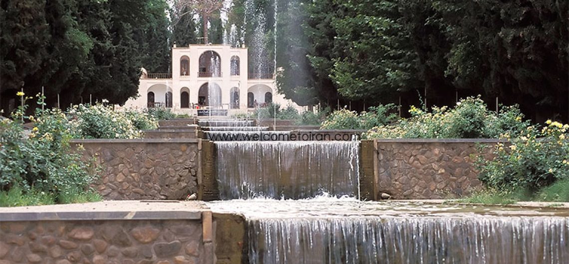
Shazdeh Mahan Garden is one of the historical gardens of Iran. This garden has 2 Kilometers distance from Mahan city, near the Kerman province and it is located on the slopes of Tigran mountain. This building is related to the end of Qajar period. The Shazdeh Mahan Garden is located in the 30 degrees and one minute of geographical peculiarities in northern latitude and 57 degree and 17 minutes of  east lengths. The height of that from the free Sea is 2020 meters. This effect in the 14 Aban 1353 came to be as one of the national monuments of Iran and in 2011 it comes to be in the list of UNESCO World Heritage.

The characteristics of the Shazdeh Mahan garden

Shazdeh Mahan Garden has the 3/5 Hectare area and has two collections of east and west. The buildings of that are very beautiful and they are making in the shapes of two floors. The entrance of that has the beautiful architecture that makes this garden distinguish from the other gardens of Iran. There are geysers or fountain in the lengths of the garden that they are the most beautiful ones in whole Iran.

These fountains are working on the basis of heights different. The length of this garden is 407 meters and the width of that is 122 meters so because of that this is the biggest and most beautiful garden of Iran. This garden has many peoples to watch it in the most times of the year especially in spring and summer.

shazdeh-mahan-garden

Locating the garden in the pass road of Kerman to Bam and in the traditional way of Silk Road was one of the factors that made this location suitable for constructing of an aristocratic garden. This garden constructed in the way that maximum visibility of internal perspectives of that is available as follow:

It is possible that on arrival, especially in the upper storey of the house entrance except for the outer garden views and perspectives, watching  Chahar Baq prospects and in the inversion of that mountain landscape.

These spectacular views it means watching the tempest of water, ponds and waterfalls each one, in turn, focuses on axes perpendicular on the main axis and with the herbal makeup obtain the uniquely internal perspective. There are many different fruit trees in this garden and in front of the mansion ponds and fountains makes the beautiful perspective either. The garden water is providing from the small Tigaran river. Mr. Masoudi has examined the building of the garden from the various aspects of architecture and the role of water inside it.

Architecture of Shazdeh Mahan Garden

Shazdeh Mahan Garden is one of the Iranian gardens and constructed in the rectangular shape land in 5/5 hectare area and has very beautiful entrance head. The garden buildings are as follow:

The main belvedere (Permanent or seasonal residence of the owner) that is locating at the end of ramping up of the garden. In the entrance head of the garden in the shape of building a front line of the entrance of the garden occupies and it is constructing in 2 floors.

shazdeh-mahan-garden

The top floor of the head door has some rooms that they are forecasting for the living and public catering establishments. The other service buildings of the garden are using the main fence and it is in the shape of the compound wall containing the service buildings in the best point of itself. In addition, this garden contains alcove mansion and bathroom.  Today the alcove mansion comes to be the restaurant and it is managing by the private sector.

History of Shazdeh Mahan Garden

Shazdeh Mahan Garden at first constructed by the hand of  Mohammad Hosein Khan Iravanian Sardar that he was the ruler of Kerman in that days and inside of garden later made by the hand of  Abdul Hamid Mirza Naser Aldoleh the governor of  Kerman during eleven years of his governance from 1298-1309 of hegira lunar. However when he died was abandoned in the half-built shape. People said that when the sudden death news of the governor arrive at Mahan one of the people who made the building left his job and has fled so it is easy to recognize some empty parts of the head of the door that they made by the hand of this man. The date of constructed the building was 1276 of Solar.

shazdeh-mahan-garden

Global registration of Shazdeh Mahan Garden

Shazdeh Mahan Garden is one of the ninth Iranian gardens that registered on the UNESCO World Heritage List in 1390 and the information of the garden is translating by UNESCO in 35 languages of the world and it is locating in the tourist map of UNESCO.Shazdeh Garden was registered in the UNESCO heritage list on the 21st of July in 2011.

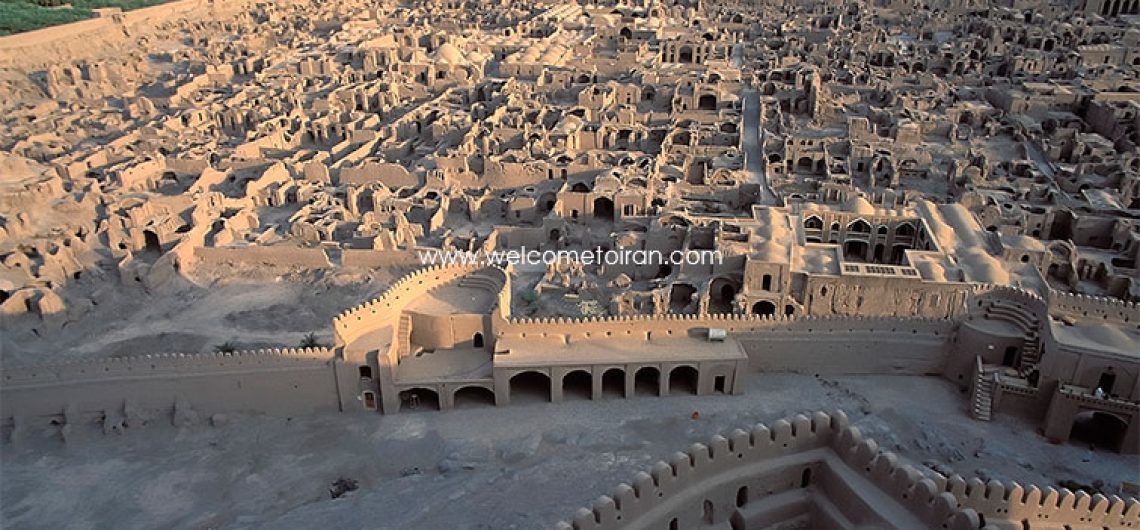
Bam Citadel is located near the city of Bam in Kerman province in southeastern of Iran and it was the largest adobe structure in the world. As a result of the severe earthquake, on 25 December 2003, that struck the city of Bam and its suburbs, Arg-e Bam was almost completely destroyed. A few days after the occurrence of the earthquake, president of Iran Mohammad Khatami said that the castle will be reconstructed.

“Arg-e Bam and its cultural space” have already been registered in the UNESCO World Heritage List. This huge organ that is in the path of the Silk Road was created in 5 century BC and continues to be used till 1850 AD. It is not clear why it was not used anymore after this time.

A total of this building is a fortress great that the organ is located, in its heart, but because of the imposing castle, that is also the highest height of this collection, the entire building called Arg-e Bam.

arg-e-bam-1

Dimensions of Arg-e Bam

The area of this citadel is about 180, 000 square meters that are composed with walls as high as 6 to 7 meters and a length of 1815 meters surrounded. This citadel is composed of two separate sections, and each of them has its own characteristics.  There have been scattered 67 towers in the ancient city of Bam.

Design and Construction of the Bam Citadel

  • Planting and architecture of Arg Citadel were evaluated from various aspects. According to the current appearance of the palace can say that the designer or designers, from the first steps of the production process, have been predicted the final shape of the building and the city. Each of the progress of made during the construction has a complete form and each additional part can easily add on to the existing.
  • Arg citadel is located in the downtown of the military city in the best view spot from military security.
  • The governmental part that is located in the inner wall contains fortress, Four Seasons Mansion, barracks, 40 meters water wells and stalls with the capacity of 200 horses.
  • The peasant settlements around the governmental state, including the main entrance of the city, along with the main route that connecting the entrance to the castle and its market, there are nearly 400 homes and public buildings such as schools and places of exercise.
  •  
arg-e-bam-3

There are 3 different types of house that there are significant:

  • Smaller houses with 2-3 rooms for poor families.
  • Larger homes with 3-4 rooms for the middle-classsociety families, which some of them has Ivan as well.
  • Luxurious houses with more rooms that are located in different parts for different seasons, with a big yard and a nearby barn for animals. The house has a very low number in this citadel. Such as Sistaniand Jewish homes.

All the buildings were made from the baked clay bricks. Bam was probably the world’s largest collection of mud brick before the 2003 earthquake.

Security in Arg-e Bam

When the city door was closed human or animal could not entrance. Residents could continue them life for long periods because they had access to water wells, gardens, and pets inside the citadel. When the military town built residents could stay inside the city and the soldiers could defend it because the castle was surrounded by high walls and towers.

arg-e-bam-4

Air conditioning in Arg-e Bam

In addition to the outline view of watchtowers and high walls decorated castle in the skyline, the magnificent painting of these building’s is magnificent loom.  Winds protruding structures of the buildings that used to catch the wind and steer it into the buildings. Sometimes Water reservoirs were built inside the building that could cool the buildings and remove dust. Buildings used for a variety of different types of wind. For example, for smaller buildings single structure louvers, and for the bigger buildings used four structure louvers till can lead the wind from different directions into the building.

arg-e-bam-5

Earth quack in 2003 in Bam

2003 earthquake in Bam destroyed more than 80 percent of this citadel. As a World Heritage many countries participated in the reconstruction of this citadel and Japan, Italy and France participated from the first. Japan helps Iran for reconstruction with about 1. 3 million dollars, by sending the equipment and create a three-dimensional plan of Bam to increase the accuracy of modernization the project will support. Italy’s Ministry of Heritage and cultural activities with the implementation of the project, with a budget of 500,000 Euros for the restoration and strengthening of tower number one will participate in the restoration of historic Citadel. The project, in collaboration with a team of experts from Italy and Iran, ended in the summer of 2011. The map helped France Citadel of Bam in Iran. The World Bank also contributed a large sum of money to this project. Bam citadel, destroyed following the earthquake in Bam and was seriously on the danger list of heritage, but according to UNESCO done in recent years in the Persian date, Tir 1392 (2003) Bam was removed from the list of in danger monuments.

arg-e-bam-6

International assistance to rebuild Bam

After the destruction of the Citadel of Bam by the earthquake, many countries helped reconstruct it. Including, Irina Bokova, Director-General of UNESCO visited the period of Historic Places on 28 April 2014 went to Bam. He said: “UNESCO is the first organization that came to the city after the earthquake. I know Monuments in the province of Kerman and Bam. Bam also started on experts actions and will continue until 2017. More than ever we try to attract financial support from foreign countries and in this regard, use the Trust Fund of Japan and other countries.


Choqa Zanbil  is an ancient Elamite Complex in the Khuzestan province of  Iran. It is one of the few existence ziggurats outside of  Mesopotamia . It lies approximately 42 km South-southeast of  Dezful, 30 km  south –east of  Susa and 80 km  north of Ahvaz.

History of Choqa Zanbil

Choqa in Bakhtiari means “hill”. Choqa Zanbil means ‘basket mound.It was built about 1250 BC by the king UntashNapirisha, mainly to honor the great god Inshushinak.

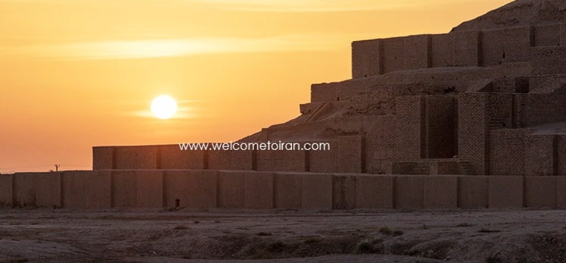
Its original name was Dur Untash, which means ‘town of Untash’, but it is unlikely that many people, besides priests and servants, ever lived there. The complex is protected by three concentric walls which define the main areas of the ‘town’. The inner area is wholly taken up with a great ziggurat dedicated to the main god,which was built over an earlier square temple with storage rooms also built by Untash-Napirishia . The middle area holds eleven temples for lesser gods. It is believed that twenty-two temples were originally planned, but the king died before they could be finished, and his successors discontinued the building work. In the outer area are royal palaces, a funerary palace containing five subterranean royal tombs.

Choqa Zanbil is an ancient Elamite Complex in the Khuzestan province of Iran. It is one of the few existence ziggurats outside of Mesopotamia.

Although construction in the city abruptly ended after Untash-Napirisha’s death, the site was not abandoned, but continued to be occupied until it was destroyed by the Assyrian king Ashurbanipal in 640 BC. Some scholars speculate, based on the large number of temples and sanctuaries at Choqa Zanbil, that Untash-Napirisha attempted to create a new religious center (possibly intended to replace Susa)which would unite the gods of both highland and lowland Elam at one site.

The main building materials in Choqa Zanbil were mud bricks and occasionally baked bricks. The monuments were decorated with glazed baked bricks, gypsum and ornaments of faïence and glass. Ornamenting the most important buildings were thousands of baked bricks bearing inscriptions with Elamite cuneiform characters were all inscribed by hand. Glazed terracotta statues such as bulls and winged griffins guarded the entrances to the ziggurat. Near the temples of Kiririsha and Hishmitik-Ruhuratir, kilns were found that were probably used for the production of baked bricks and decorative materials. It is believed that the ziggurat was built in two stages. It took its multi-layered form in the second phase.

The ziggurat is considered to be the best preserved example in the world. In 1979, Chogqa Zanbil became the first Iranian site to be inscribed on the UNESCO World Heritage List.

chogha-zanbil-ziggurat-2

Archaeology of Choqa Zanbil

Choqa zanbil was excavated in six seasons between 1951 and 1961 by Roman Ghirshman.

Threats of Choqa Zanbil

Petroleum exploration due to increased global demand threatens the foundations of  the site , as various seismic tests have been undertaken to explore for reserves of  petroleum. Digging for oil has been undertaken as close as 300 metres away from the ziggurat.

chogha-zanbil-ziggurat-3

Reference: https://en.wikipedia.org/wiki/Chogha_Zanbil

Shahr-e Sukhteh (Shahr-i Sokhta), meaning ‘Burned City’, is located at the junction of Bronze Age trade routes crossing the Iranian plateau. This ancient city is at a distance of 60 km. from Zabol and 6 km. from the Rostam Castle, and is comprised of hillocks with a maximum elevation of 50 m. This vicinity was one of the vital centers of Asian civilization in the bronze age, and dates to the 4th and 3rd millennium BC. Archaeological and scientific discoveries, have revealed a rectangular structure, with square chambers, a corridor, staircase and walls to the thickness of 3 m. to the rear of this archaic structure, that show the signs of a vast fire.

Another vestige of the Achaemenid period, discovered in the excavations in hillocks of this area, is a bronze statue of a woman carrying an urn on the head. Colored earthenware found in Shahr-e Sukhteh are related to the 4th, 3rd and 2nd millennium BC. and are similar to the civilizations of Mesopotamia and India.

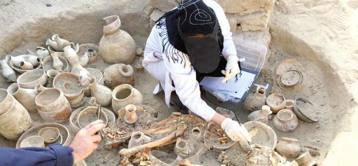
There were four stages of civilization living there. Before it was abandoned, the city had been burned down three times. Therefore, many had lost their lives. As a result, there’s a sizable graveyard attached to this settlement that has accommodated from 25,000 to 40,000 ancient graves.

Archaeological Importance of Shahr-e Sukhteh

There’s no doubt that this ancient human settlement is indebted its significance to the interesting artifacts unearthed there. Several items have been discovered in relatively very good condition and unique objects have indicated a brilliant civilization at Eastern part of Iranian plateau.

The List of some of the most outstanding unearthed items:

  • The skull of a 14-year old girl indicating traces of practicing brain surgery. She had eventually died as a result of the diagnosed illness,
  • An earthen-made goblet depicting a goat in different running positions around it, which represents the first world’s animation example when turning,
  • The oldest backgammon & dice ever discovered in the world indicating people used to play this game back then,
  • An artificial eyeball, which is known as the earliest example of its kind, made of a thin layer of gold on a light material,
  • A 10-cm ruler with high precision that indicates the mastery over mathematics by these people,
  • Beautifully painted motifs on a piece of leather together with several other fabrics each one dyed in several colors,
  • Unique marble vessel beautifully shaped unearthed from the grave of a young woman between 28 and 30 years of age,
  • And hundreds of other fascinating objects like an incense burner mounted on a mirror, colorful jars, very delicate necklaces, charcoal holders, seals, pottery and jewelry workshops, etc.

 Cultural Importance of Shahr-e Sukhteh

Culturally, it has been a rich city associated with Jiroft culture. In other words, this ancient site has been a human settlement independent of ancient Mesopotamia. Several discoveries have contributed to the fact that Shahr-e Sukhteh must have had a particularly remarkable culture. Here are some of them:

  • According to some paleoanthropologists, women had a pivotal role in social aspects and financial fields of the families. Only inside some of women’s graves, particular type of insignias had been unearthed distinguishing prominent members of the society from the others.
  • The skeleton of a professional camel rider suggests he had been a courier delivering parcels, messages over long distances.
  • According to the excavations carried out at the Burnt City, there were farmers and craftsmen among various guilds working in this ancient settlement. Weavers who made carpets, baskets, etc, by teeth, were some of the main guilds who made several different items. Lots of teeth have been unearthed in Shahr-e Sukhteh.

In addition, the culture beyond some of the practices and discoveries mentioned above (like artificial eyeball, brain surgery, ruler, backgammon, etc) are all indicative of a rich culture prevailing in this human settlement of the Bronze Age in South East of Iran.

The Fall of Shahr-e Sukhteh

According to the researchers, what led to the end of the civilization at this human settlement was a consequence of diversion in the courses of water and climate change. This area used to be quite humid with abundant sources of water and lots of trees. The inhabitants used to burn wood for fuel. As a result of less sources of water and more heat, the inhabitants abandoned the city and things fell apart.

More Archaeological Exploration Underway

A lot of excavations are performed at all the historical mounds of Shahr-e Sukhteh. From time to time, there’s another news story about some new finding at this site. It should also be added that it’s not easy to carry out the archaeological excavation at this site due to the hostile climate of the region. Sand storm, high temperature of desert, etc are some of the difficulties the experts have to deal with.

However, some experts are working on the diet of people. They had found out that lentils and fish were some of the main foodstuff people used to eat there. More information will be coming out as more work is being done.

In Ardestan, Iran, there is a Qanat with two levels of water lying over each other, called the Moon Qanat. The 1st level is 30 meters deep, and the 2nd level is 27 meters deep, so the high difference is 3 meters. The soil formation of Moon Qanat is such that the water from 2nd level does not penetrate the lower level. The strangest qanat in Iran is the two-storey qanat of Moon-e Ardestan that was built approximately 800 years ago; it has ordinary wells together with different mother wells and side wells.

The Structure of Moon Qanat

The Qanat of Mun (Moon Qanat) is a 2km long, two-story qanat, having two main tunnels with one mother well each. The lowest tunnel is 30m down and is separated by the above tunnel by 3m of elevation. This top tunnel goes through a half circle path when it reaches the vertical shafts. The layer between the tunnels is impermeable, so water does not leak between them . However, the tunnels do share all other wells besides their mother wells. The entire Moon Qanat has 30 shafts that are spaced 42.4m apart. Its average outward flowrate is 50 liters per second.

“Ancient Iranians invented a new system to bring the groundwater to the surface using gravitational force”, called “Qanat”

What is Qanat System?

The qanat is a method for developing and supplying groundwater and consists of a gently sloping tunnel, cut through alluvial material, which leads water by gravity flow from beneath the water table at its upper end to a ground surface outlet and irrigation canal at its lower end. Qanats are constructed by the hand labour of skilled workers known as Muqannis using techniques which have altered little since qanat construction began.
The qanat system within an area represents a traditional response to the problem of water supply and irrigation and is a particularly characteristic feature of the landscape of Iran.

Qanat is an underground gallery that conveys water from an aquifer or a water source to less elevated fields. In practice, a Qanat consists of a series of vertical shafts in sloping ground, interconnected at the bottom by a tunnel with a gradient more gentle than that of the ground. The first shaft (mother well) is sunk, usually into an alluvial fan, to a level below the groundwater table. Shafts are sunk at intervals of 20 to 200 meters in a line between the groundwater recharge zone and the irrigated land. From the air, a Qanat system looks like a line of anthills leading from the foothills across the desert to the greenery of an irrigated settlement.

The Story of Moon Qanat

The famous Qanat, in the Mun district, is the world’s only two-story qanat. Legend says that once a qanat-builder from Yazd stopped in Mun for a night. In the morning before departure, he told the locals that he had heard the murmur of underground waters and encouraged them to build a qanat on the site he had shown. On his way back, he stopped in Mun again and was very surprised to see that the qanat had been built on a different level from what he had suggested. The construction started anew, and another floor of the Moon Qanat came into being. Remarkably, the water of the two canals never mixes.